


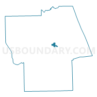
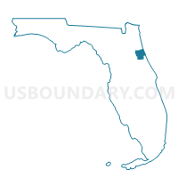
DRCDD-Dear Run CDD, Flagler County, Florida
About
Outline

Summary
| Unique Area Identifier | 553334 |
| Name | DRCDD-Dear Run CDD |
| County | Flagler County |
| State | Florida |
| Area (square miles) | 1.10 |
| Land Area (square miles) | 1.09 |
| Water Area (square miles) | 0.00 |
| % of Land Area | 99.61 |
| % of Water Area | 0.39 |
| Latitude of the Internal Point | 29.48583250 |
| Longtitude of the Internal Point | -81.25433490 |
Maps

Graphs
Select a template below for downloading or customizing gragh for DRCDD-Dear Run CDD, Flagler County, Florida


Neighbors
Neighoring Voting District (by Name) Neighboring Voting District on the Map
- 1A-Voting District, Flagler County, FL
- 1B-Voting District, Flagler County, FL
- 32A-Voting District, Flagler County, FL
- 5A-Voting District, Flagler County, FL